Affiliate Disclosure: This site contains affiliate links. If you book through these links we may earn a small commission, at no extra cost to you.
GR34 Roscoff: Complete 2026 Walking Guide to the Sentier des Douaniers
The GR34 Roscoff section has one quality that sets it apart from every other section of France’s greatest long-distance walk: it begins at a British ferry port. Step off the Armorique at Port de Bloscon, walk 400 metres to Quai d’Auxerre, and you are on the GR34 — the Sentier des Douaniers, the 2,106km customs officers’ path that traces the entire Breton coastline. No car required, no taxi, no transfer. The path is there.
What you walk into depends entirely on which direction you choose. East from Roscoff, the path enters the rocky, island-scattered Baie de Morlaix — a deeply indented coastline of granite headlands, tidal islands and views to the Château du Taureau, past Carantec’s extraordinary Penn al Lann viewpoint, the dramatic cliffs of the Pointe de Primel, and the wild clifftop at Beg an Fry to the headland resort of Locquirec. This section — between Locquirec and Saint-Pol-de-Léon — was specifically named in the 2018 FFRandonnée poll as a highlight of France’s favourite long-distance trail. West from Roscoff is a completely different character: the Côte des Sables and Côte des Légendes, where the path crosses 45 kilometres of wild, sandy coast — open beaches, dune systems, granite chaos, and the remarkable port of Moguériec with its restored Gustave Eiffel lighthouse, one of only three such structures still standing in France.
This complete 2026 guide covers the GR34 coastal path from Roscoff in both directions: the best local day walks, the multi-day stages east to Locquirec and west to Brignogan, key landmarks section by section, BreizhGo bus return options, and the best seasons to walk.
Last updated: May 2026 | Distances, landmarks and transport verified from official sources
GR34 Roscoff — France’s Favourite Long-Distance Trail 2018 | Step off the Armorique and onto the path | Rocky Morlaix Bay East | Wild Cote des Sables West | Eiffel Lighthouse | Keremma Dunes | No Car Required
✅Step off the ferry and onto the path — Quai d’Auxerre, Roscoff, is just 400 metres from Port de Bloscon. The GR34 red-and-white waymarks begin here. No taxi, no transfer, no car required.
✅Pointe de Perharidy Loop (10km, ~2.5hrs) — the best local day walk from Roscoff: wild peninsula, white sand beach at Plage du Pouldu, constant views to Ile de Batz. The perfect walk to do the morning after an overnight crossing.
✅East: Rocky Morlaix Bay (Roscoff to Locquirec) — dramatic indented coastline past Carantec’s Penn al Lann viewpoint, Cairn de Barnenez, the clifftops of Pointe de Primel, Beg an Fry and Locquirec. The section voted France’s favourite.
✅West: Cote des Sables and Cote des Legendes — a completely different character: flat, wild, duneland coast past the Eiffel lighthouse at Moguériec, the 6km Keremma dunes, the ornithological reserve at Goulven, and the wrecker village of Meneham.
✅BreizhGo Ligne 929 — the bus linking Roscoff to Morlaix (~45 min, Mon–Sat), connecting the eastern sections of the GR34 to the TGV network at Morlaix Gare SNCF.
ℹ️The path in two directions — Roscoff sits mid-route on the northern GR34. East leads into the rocky drama of Morlaix Bay; west into the wild sandy Cote des Legendes. Two completely different walks from the same ferry port.
What Is the GR34? France’s Greatest Coastal Path
The GR34 — the Sentier des Douaniers — is the backbone of coastal walking in Brittany. Created in 1791 as a patrol route for customs officers fighting smuggling along the wildly indented Breton coastline, the path fell into disuse in the early 20th century and was painstakingly restored from 1968 by hiking volunteers before being incorporated into France’s Grande Randonnee network. Today it runs 2,106km from Mont-Saint-Michel to Saint-Nazaire, tracing every bay, headland, cove and estuary of the Breton coast.
France’s Favourite Trail — and Why the Roscoff Section Won
In 2018, the FFRandonnee asked walkers across France to vote for their favourite long-distance route. The GR34 won. Among the sections highlighted in the poll was the stretch between Locquirec and Saint-Pol-de-Leon — a section that passes directly around Roscoff. This part of the GR34 offers a combination of genuinely wild coastline, extraordinary variety of terrain, and a landscape shaped by the sea in ways that feel more elemental than any other section of the trail.
The GR34 is also the French section of the E9 — one of Europe’s 11 official long-distance hiking routes, running from Cabo de São Vicente in Portugal to the coast of Estonia. Walkers completing the GR34 from Roscoff are walking on one of the great European long-distance routes. The northern GR34 from Mont-Saint-Michel to Roscoff — covered by the Cicerone guidebook by Carroll Dorgan — runs 624km in 28 stages of between 13 and 33km. Most walkers tackle it in sections of 5–7 days rather than the full month. For Plymouth–Roscoff ferry passengers, the path begins at the port gates — and what lies either side is walking of genuine international quality.
East: Rocky Morlaix Bay Character
East of Roscoff, the GR34 follows the Baie de Morlaix coast — an intricate, rocky shoreline of granite headlands, tidal islands and deep estuaries. The terrain is more demanding: frequent short climbs and descents, cliff-edge paths, and sections that are tide-dependent. The views are constantly changing and the sense of remoteness is real. The onion fields of the Leon — artichokes and cauliflowers that feed half of France — sit directly behind the coastal scrub.
West: Cote des Legendes Character
West of Roscoff is the flattest section of the northern GR34 — a remarkable contrast to the rocky east. The Cote des Sables (Coast of Sands) gives way to the Cote des Legendes (Coast of Legends), named for ancient stories embedded in every boulder and cove. The path crosses 22km of white sand beaches, long dune systems, low granite chaos and the extraordinary light of northern Finistere. The terrain is significantly easier — a genuine option for walkers of all fitness levels.
Local Day Walks from Roscoff on the GR34
Three walks suit different time frames and abilities. All begin from Roscoff old town or port — no car needed for the start, and the first is a loop returning to Roscoff.
GR34 Walks from Roscoff — Distances and Times
Walk
Distance
Time
Grade
Highlight
Perharidy Loop
~10km
~2.5 hrs
Easy
White sand beach, Ile de Batz views. Returns to Roscoff.
Roscoff → Moguériec (west)
~13km
~3.5 hrs
Easy/flat
Eiffel lighthouse, sandy coast. One-way.
Roscoff → Carantec (east)
~20km
5–6 hrs
Moderate
Ile Callot, Penn al Lann viewpoint. Return by car/bus.
Roscoff → Morlaix (east, 2 days)
~47km
2 days
Moderate
Cairn de Barnenez, Morlaix viaduct. BreizhGo return.
All distances are approximate. Times assume a relaxed pace with stops. Verify current route with GPX from mongr.fr before setting out.
The Best Local Walk: Pointe de Perharidy Loop from Roscoff
For anyone arriving on the overnight ferry and wanting to walk the GR34 Roscoff without a car or forward planning, the Perharidy loop is the essential starting point — a complete walk that begins and ends in Roscoff old town, covers the best local section of the path, and is manageable in a morning before heading south.
Perharidy Loop — ~10km, ~2.5 Hours, Easy, FREE
Start/End: Roscoff old town (Vieux Port or Quai d’Auxerre) | Grade: Easy — low elevation gain, some tidal sections | Best at: Low tide for the beach section at Plage du Pouldu
The route follows the GR34 west from Roscoff, skirting the edge of the town and then opening onto the Breton coastal path proper. Within the first kilometre you leave Roscoff’s streets behind and the path narrows between the sea and the granite outcrops. Ahead, across the water, Ile de Batz fills the view — its lighthouse clearly visible, the ferry boats crossing back and forth throughout the morning.
The path rounds the Pointe de Perharidy and descends to Plage du Pouldu, a beach of remarkable white sand that feels entirely incongruous with the rugged granite coast on either side. At low tide the beach stretches wide; at high tide the path takes a short inland diversion. The views across to Ile de Batz are among the finest on this section of coast.
From Plage du Pouldu, the route loops back to Roscoff via country lanes and field paths through the agricultural hinterland — past artichoke and cauliflower fields that are a reminder this is the Leon, the most productive vegetable-growing area in France. Practical note: The beach section at Plage du Pouldu is best at low tide. A GPX file is available from mongr.fr or from the Roscoff tourist office. A simple crêperie opens near the beach in summer months.
West from Roscoff: The Cote des Legendes — Key Landmarks
The GR34 heading west from Roscoff enters a landscape that could not be more different from the rocky Morlaix Bay section east: the Cote des Sables opens into the Cote des Legendes — wide, flat, wild and extraordinary. Here are the landmarks in sequence.
🏖️ Plage du Dossen and Ile de Sieck (~5km west)
Just west of Santec, the path reaches the vast Plage du Dossen — a wide, open beach with the Ile de Sieck visible offshore. The character shifts dramatically: the close-packed granite of Roscoff gives way to wide skies, open sea, and sand stretching to the horizon. Ile de Batz is still prominent across the water. This is the beginning of the Cote des Sables proper — the walking becomes easier and the sense of space expands.
🚨 Port de Moguériec and the Eiffel Lighthouse (~13km west)
Moguériec is a compact crabbers’ and lobster port — once the largest lobster port in France — at the mouth of the Penzé river, Sibiril. At its entrance stands the Phare de Moguériec, a 9-metre cast-iron lighthouse designed by Gustave Eiffel in 1876 and originally installed at Honfleur in Normandy. One of only three Eiffel lighthouses still standing in France, it was threatened with demolition in 2015. The local community raised EUR540,000 to restore it — a project completed in 2023. It now stands restored and lit at the port entrance: a uniquely intimate piece of French maritime heritage passed directly by the GR34.
🌾 Dunes de Keremma (~20km west)
The Dunes de Keremma are the longest dune system in Brittany — 6km of white dunes stretching between the Anse du Kernic and Plouescat, protected by the Conservatoire du Littoral and designated Natura 2000. The GR34 crosses the full length on a path between the sea and the dune crest. The Maison des Dunes interpretation centre stands 200m from the path. The Anse du Kernic tidal inlet at the eastern end can be crossed on foot at low tide but is dangerous at high tide or when the tidal coefficient exceeds 80 — a road diversion is provided. The combination of white sand, blue sea and the vast skies of northern Finistere is among the most visually striking sections of the entire northern GR34.
🐦 Anse de Goulven — Bird Reserve (~25km west)
Beyond Keremma, the path reaches the Anse de Goulven — a wide, shallow bay that is also a protected ornithological reserve. The tidal mudflats attract thousands of wading birds on autumn and winter passage: dunlin, oystercatcher, grey plover, knot and curlew are all regular. The bay is also an important breeding site for tern species. Birdwatchers should bring binoculars — the open exposure of the path gives unobstructed views across the bay.
🪨 Meneham — The Village of Wreckers (~35km west)
Meneham, in the commune of Kerlouan, is one of the most remarkable settlements on any coastal path in France — a cluster of houses and outbuildings built directly into and among enormous granite boulders at the cliff edge. Historically associated with coastal wreckers (naufrageurs) who were said to lure ships onto the rocks, the village is now a protected heritage site. The houses are so integrated into the granite that the boundary between human construction and natural rock is genuinely ambiguous. A short diversion from the GR34 brings you into the village from the coastal path.
🗿 Brignogan-Plages — Menhir on the Beach (~40km west)
The natural western destination for a multi-day walk from Roscoff, Brignogan-Plages has a remarkable feature: the Menhir de Cam Louis, a prehistoric standing stone that stands directly on the beach at the water’s edge at certain states of the tide. The contrast between the prehistoric stone, the Breton sea, and the extraordinary quality of light on this coast is one of the most photographed scenes in the region. Brignogan has accommodation, a campsite, and local bus connections for return.
East from Roscoff: Morlaix Bay — Key Landmarks
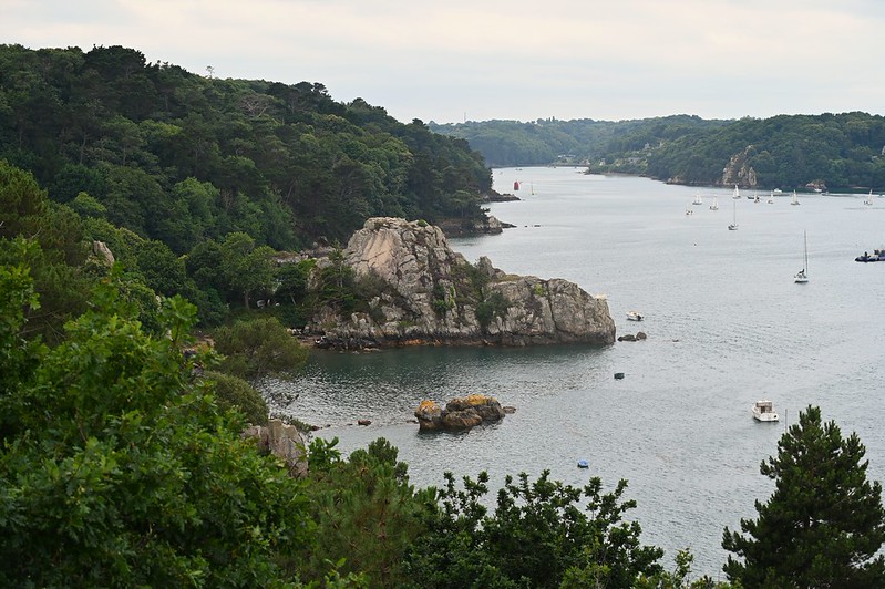
East from Roscoff, the GR34 enters the rocky, island-scattered Baie de Morlaix — the section that contributed to the trail’s 2018 national award. Here are the key landmarks in sequence from Roscoff.
Stage 1: Roscoff to Carantec (~20km)
Waypoints: Roscoff Quai d’Auxerre → Chapelle Sainte-Barbe → Saint-Pol-de-Leon (1.5km detour) → Pempoul → Ilot Sainte-Anne → Penn al Lann → Ile Callot (tidal) → Carantec
The path leaves Roscoff past the Chapelle Sainte-Barbe (1619) on the promontory above Port de Bloscon — one of the best viewpoints in the immediate area, with the ferry terminal visible below. The route then follows the estuary of the Penzé river, passing artichoke and cauliflower fields that line the path — the Leon responsible for a large proportion of France’s vegetable production. At various points along the estuary the views open to Carantec on the far bank.
The path arrives at Penn al Lann — Carantec’s extraordinary headland viewpoint. From here, Ile Louet with its lighthouse, the Chateau du Taureau on its rocky islet in Morlaix Bay, and the tidal Ile Callot (accessible on foot at low tide via an 800-metre causeway) are all directly in view. This is one of the finest viewpoints on the entire Finistere section of the GR34.
Stage 2: Carantec to Plougasnou via Morlaix and Cairn de Barnenez (~27km)
Waypoints: Carantec → Morlaix → Locquénolé → Cairn de Barnenez (5km from path) → Terenez → Port du Diben → Pointe de Primel → Plougasnou
The path reaches Morlaix — a town worth at least half a day, dominated by its extraordinary two-storey viaduct (1861) and the medieval half-timbered streets of the old town — before continuing east. Cairn de Barnenez, the largest megalithic monument in Europe (~4,500 BC), stands approximately 5km from the coastal path on its headland above the bay — a short diversion from the GR34 that no serious walker should omit.
The most dramatic section of this stage is the Pointe de Primel — a rocky headland that requires sure-footing and involves genuine scrambling on the descent. The views from the headland across Morlaix Bay to the Sept Iles archipelago are among the best on any section of the northern GR34. A road diversion is available but misses the finest scenery. This section is not suitable for anyone with vertigo.
Stage 3: Plougasnou to Locquirec — The Favourite Section (~13km)
Waypoints: Plougasnou → Saint-Jean-du-Doigt → Beg an Fry → Moulin de Trobodec → Moulin de la Rive → Locquirec
This is arguably the finest section of the GR34 in Finistere — the stretch the FFRandonnee specifically cited when the trail won its 2018 award. The path climbs above the sea on exposed clifftops of purple heather and yellow gorse, passing the WW2 Resistance commemorative marker at Beg an Fry — a clifftop point from which the view on a clear day takes in the Sept Iles archipelago and the full arc of the Brittany coast. A deep valley leads to the Moulin de Trobodec — an old watermill in a wooded gorge, where Highland cattle graze the valley floor. The incongruity of Scotland’s cattle in deepest Finistere is one of those GR34 details that walkers remember long after the landscapes have blurred.
The path arrives at Locquirec via the Moulin de la Rive car park — the most popular starting point for day-walkers on this section. The resort itself is a beautiful Breton coastal village with a headland, beaches and restaurants. This makes a useful end point if you want to be collected by car or return by bus to Morlaix, then Ligne 929 back to Roscoff.
Getting Back to Roscoff: BreizhGo Bus and Transport
The GR34 Roscoff is best walked as a linear route rather than retracing your steps — which means planning your return in advance.
The Ligne 929 is the essential return connection for walkers on the eastern section. If you walk east from Roscoff to Morlaix (~47km, 2 days), you can return from Morlaix Gare SNCF directly to Roscoff on Ligne 929. The bus also stops at Saint-Pol-de-Leon, useful if you walk only the first section. Note: departures are infrequent — check current timetables at breizhgo.bzh before planning your return. Morlaix TGV: Morlaix has direct TGV services to Paris (~3hrs). If you have walked the full section, this is how you connect to the national rail network.
Warning: The Ligne 929 does not stop at intermediate coastal points (Carantec, Plougasnou, Locquirec) — these require additional local transport or a car at the far end. West from Roscoff: bus connections are very limited on the Cote des Legendes — plan a car shuttle or return walk for this direction.
💡 Best One-Way Walk Combinations from Roscoff
Morning walk (2.5–3 hrs): Perharidy loop from Roscoff — starts and ends in town. No transport needed. Best after overnight ferry arrival.
Half day east (5–6 hrs): Walk Roscoff to Carantec (~20km). Arrange car at Carantec or taxi to Morlaix for Ligne 929 bus back.
Two days east: Roscoff → Morlaix via GR34 (~47km). Stay overnight in Carantec or Plougasnou. Return from Morlaix on Ligne 929 to Roscoff. The most rewarding option combining the best of Morlaix Bay coastline.
West to Moguériec: Walk ~13km west to the Eiffel lighthouse. Pre-arrange a car shuttle or return walk on the same day.
Navigation, Gear and Season
🗺️ Navigation
The GR34 Roscoff is waymarked throughout with red-and-white horizontal paint stripes. Through villages and where the route joins roads, look at head height on gateposts and walls. Free GPX tracks for every section including the Roscoff area are at mongr.fr (official FFRandonnee website). Relevant IGN 1:25,000 map: reference 0515ET (Saint-Pol-de-Leon, Roscoff, Ile de Batz). The Cicerone guidebook by Carroll Dorgan covers every stage from Mont-Saint-Michel to Roscoff in detail. The Hiiker app (hiiker.app) provides an interactive digital map of the entire GR34 with points of interest, accommodation and distances — a useful complement to the GPX files from mongr.fr, particularly for identifying water points and refreshment stops along the route.
🧳 Gear Essentials
Non-negotiable: waterproof trail shoes or walking boots (not road trainers — the eastern section is rocky and muddy), windproof waterproof jacket (the exposed headlands east of Roscoff have no shelter from Atlantic squalls), at least 1.5 litres of water per person for any walk over 10km. Note on walking poles: rubber caps are required on all sections of the GR34 in Brittany — metal tips damage the path surface and are prohibited. Sunscreen: the clifftop sections are very exposed even in spring and autumn.
📅 Best Seasons
May–June: The best months. Gorse and broom at their peak on the clifftops, daylight until 10pm in June, temperatures pleasant (12–19℃), path not crowded. The light on the northern Finistere coast in May is extraordinary. September: Excellent — crowds have gone, accommodation easier, heather is purple on the clifftops. July–August: Warm and long days, all facilities open, but busiest sections can be crowded. Start by 08:00. Winter: The western section (Cote des Sables) is excellent in any weather — flat, exposed, dramatic. The eastern section in an Atlantic gale is a serious undertaking.
🌊 Tides — Essential Reading
Several sections around Roscoff are tide-dependent. The Plage du Pouldu section (Perharidy loop) and the Anse du Kernic crossing at Keremma are only accessible at low tide — both have road diversions when flooded. Ile Callot at Carantec is crossable only 2 hours either side of low water. Check tide times for Roscoff at tide-forecast.com before any walk involving these sections. Signed road diversions are always provided; use them rather than attempting a submerged crossing.
Multi-Day Walking: Accommodation, Food and Luggage Transfer
The GR34 from Roscoff is an outstanding multi-day walking itinerary — suited to anyone arriving on the Plymouth ferry with 2–5 days to walk the coast. Here is everything you need for an overnight or multi-day trip.
🏠 Accommodation on the GR34 from Roscoff
The GR34 Roscoff and Morlaix Bay section is well served for walkers. Gîtes d’étape (walkers’ hostels providing bunk beds, hot meals and a convivial atmosphere) are the classic GR34 accommodation option — the FFRandonnée maintains an official list at mongr.fr. Chambres d’hôtes (French B&Bs) in Roscoff, Carantec, Plougasnou and Morlaix are excellent: typically family-run with evening meals available. Look for the Étape Rando Bretagne and Rando Accueil labels — the official quality marks for walker-friendly accommodation on the GR34, guaranteeing drying rooms, secure equipment storage and walker-specific services. The baiedemorlaix.bzh tourism office lists GR34 accommodation on its website.
🧳 Luggage Transfer: La Malle Postale
La Malle Postale is the specialist luggage transfer service for GR34 walkers in Brittany. They collect your bag from your accommodation each morning and deliver it to your next overnight stop, leaving you free to walk with only a daypack. This transforms a multi-day walk from a laden slog into a genuine pleasure. FFRandonnée Rando Pass holders receive a 5% discount. Book in advance — the service is popular in July and August. Visit lamallepostale.com for current coverage, prices and booking. Ensure your accommodation can receive delivered luggage before booking the service.
🥞 Eating on the GR34 from Roscoff
The GR34 from Roscoff passes through some of the finest food country in northern Brittany. The galette — the buckwheat crêpe that originated in Brittany — is the essential walkers’ lunch: filling, cheap, and available at crêperies in almost every village. Roscoff itself has excellent seafood: the artichokes, cauliflowers and onions grown in the fields you walk through are served in local restaurants alongside fruits de mer (seafood platters), oysters and mussels from the Morlaix Bay beds. Kouign-amann — the dense, caramelised Breton butter cake — and local Breton cider are the classic post-walk rewards. In the villages west of Roscoff on the Côte des Légendes, facilities thin out significantly — carry lunch and snacks for the Keremma and Meneham sections, where there are no refreshment stops on the path itself.
GR34 Roscoff: Frequently Asked Questions
Where does the GR34 start in Roscoff?
The GR34 Roscoff passes through the old town and port. The practical starting point for ferry arrivals is Quai d’Auxerre — approximately 400 metres from the Port de Bloscon ferry terminal gate. Walk left out of the port gate along the coast road and follow the GR34 red-and-white waymarks into the old town. The path runs both east (towards Saint-Pol-de-Leon and Carantec) and west (towards Santec and the Cote des Sables). Roscoff is both the northern terminal of the Cicerone guide’s 624km route and a mid-point of the full 2,106km GR34 circuit.
What is the best day walk on the GR34 from Roscoff?
For most visitors arriving on the ferry, the Pointe de Perharidy loop (~10km, ~2.5hrs, easy) is the best introduction to the GR34 Roscoff — it starts and ends in Roscoff, covers the finest local section of the GR34, includes a remarkable white sand beach with constant views to Ile de Batz, and is manageable as a morning walk before heading south. For those with more time, the eastern section towards Carantec (20km one way, 5–6hrs) is more dramatic and includes the Penn al Lann viewpoint and Ile Callot. The walk from Plougasnou to Locquirec via Beg an Fry is the section voted part of France’s favourite GR trail in 2018.
Is there a bus back to Roscoff from the GR34?
Yes, for the eastern section: BreizhGo Ligne 929 runs between Roscoff and Morlaix (Gare SNCF) Monday to Saturday, stopping at Saint-Pol-de-Leon. Journey time approximately 45 minutes. Buy your ticket on board. If you walk east as far as Morlaix, this bus returns you directly to Roscoff. For other points (Carantec, Plougasnou, Locquirec), a taxi to Morlaix and then Ligne 929 back is the practical return. Check current timetables at breizhgo.bzh before planning. West from Roscoff (Cote des Legendes): bus connections are very limited — plan a car shuttle or return walk for this direction.
How do I download a GPX file for the GR34 near Roscoff?
Free GPX downloads for all GR34 sections around Roscoff — including west towards Guisseny and east towards Morlaix — are at mongr.fr (the FFRandonnee’s official walking website). Search for “GR34 Roscoff” and select the relevant section. The GPX files are compatible with any GPS app including OS Maps, Komoot, Gaia GPS and Google Maps. The relevant IGN 1:25,000 paper map is reference 0515ET (Saint-Pol-de-Leon, Roscoff, Ile de Batz).
What is the Eiffel lighthouse at Moguériec?
The Phare de Moguériec at the port of Moguériec, Sibiril — approximately 13km west of Roscoff on the GR34 — is a 9-metre cast-iron lighthouse originally designed by Gustave Eiffel and built in 1876 for the port of Honfleur in Normandy. It is one of only three Eiffel lighthouses still standing anywhere in France. Threatened with demolition in 2015, the local community formed an association and raised EUR540,000 to restore it. The restoration was completed and the lighthouse re-inaugurated in September 2023. It stands at the port entrance and is passed directly by the GR34 coastal path heading west from Roscoff.
Continue Planning Your Plymouth to Roscoff Trip
🌊
Carantec Day Trip
The GR34’s first major eastern destination — Penn al Lann viewpoint, Ile Callot tidal island, Maritime Museum
Brittany Ferries sails year-round from Plymouth Millbay to Roscoff. The GR34 red-and-white waymarks are 400 metres from the port gate. France’s favourite long-distance trail begins where the ferry ends.
This website uses cookies to improve your experience. If you continue to use this site, you agree with it.
We use cookies to ensure that we give you the best experience on our website. If you continue to use this site we will assume that you are happy with it. We also use affiliate links, please see our privacy policy.